The United Kingdom of Great Britain and Northern Ireland (UK) is bordered by four seas: to the south by the English Channel, which separates it from continental Europe; to the east by the North Sea; to the west by the Irish Sea; and the Atlantic Ocean.
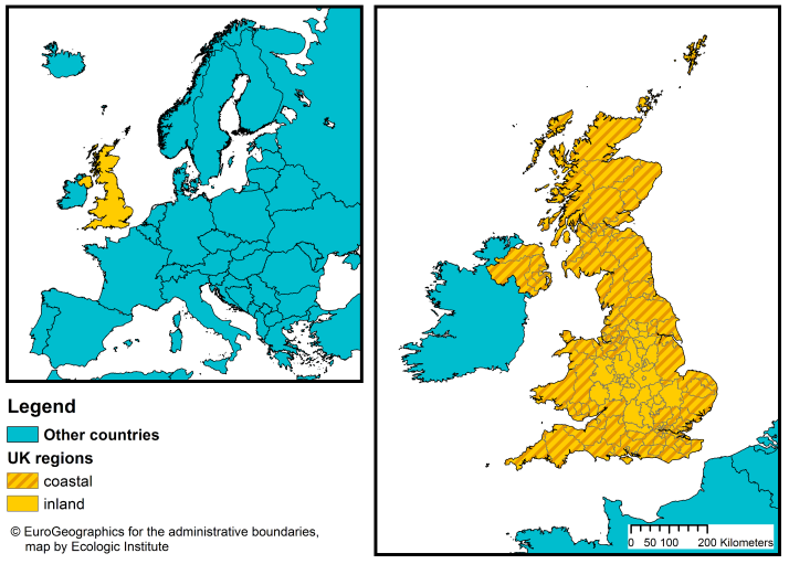
Around 78 % of the population (50.885.219 inhabitants) live in coastal regions1, as compared with the EU-28 average of 42 % (Eurostat, 2015).2 135 of the UK's 173 upper tier (or groups of lower tier) authorities are coastal (see Figure 1).
Figure 1: Map of administrative regions in the UK at NUTS-3 level3
The United Kingdom (UK) is an asymmetrically decentralised unitary state, comprised of England and three countries with devolved governments: Scotland, Northern Ireland and Wales. The UK Parliament retains absolute sovereignty, while the Scottish Parliament, the Northern Ireland Assembly and the National Assembly for Wales, each has a differing degree of devolved legislative powers (CoR, 2012). There are three legal systems within the UK: 1) England and Wales 2) Northern Irish and 3) Scottish.
Successive reforms have produced a complex set of bodies which are responsible for delivering public services at the local level in the UK (CoR, 2012).
Table 1: Overview of territorial divisions in the UK using Nomenclature of Territorial Units for Statistics (NUTS) and LOCAL ADMINISTRATIVE UNITS FOR STATISTICS (LAU). SOURCE: Office for National Statistics UK, May 2016
| NUTS level | Name | Total units | Coastal units |
|---|---|---|---|
| NUTS 1 |
Countries (N.Ireland, Scotland, Wales) + Statistical regions in England |
3 + 9 | 3 + 8 |
| NUTS 2 |
Counties (some grouped); Inner and Outer London; Groups of unitary authorities |
40 | 32 |
| NUTS 3 | Upper tier authorities or groups of lower tier authorities (unitary authorities or districts) | 173 | 135 |
| LAU 1 | Lower tier authorities (districts) or individual unitary authorities; Individual unitary authorities or LECs (or parts thereof); Districts | 415 | 321 |
| LAU 2 | Wards (or parts thereof) | 10126 | 7998 |
The remainder of this page focuses on the governance system in England where the RISC-KIT case study area of North Norfolk is located.
In some parts of England, local government is divided into a two-tier system, split between county councils at the upper tier and district councils at the lower tier. Each tier is responsible for different services, although they overlap in some matters (Sandford, 2017). In other areas there is no tiered system, and 'unitary authorities' carry out all local government functions. In total, England has 353 local authorities: 27 county councils; 201 district councils; and 125 unitary authorities (Sandford, 2017).
In 2011, the Localism Act was passed with the aim of bringing about greater decentralisation and to shift the balance of power towards local authorities. Nonetheless, a 2014 Council of Europe report on local and regional democracy noted several areas of concern, including the limited financial independence of local authorities and their limited discretion to manage local affairs due to 'intervention by various ministries of the central government' (CoE, 2014).
A number of national organisations have been established by central government to carry out functions and/or distribute funding in England and Wales (e.g. the Environment Agency, Natural England and the Homes and Communities Agency). Although many local authorities may have working relationships with these bodies, they are are not accountable to local government (Sandford, 2017).
Although Busch et al. (2016) argues that compared to other western EU countries, the UK does not have a long tradition of systematically incorporating civil society in political decision-making, flood and coastal risk management is an area that has been routinely engaging and including the public for many years (Alexander et al., 2016). Furthermore, since 2010, significant efforts have been made to increase policymaking transparency and to pursue greater levels engagement with non-governmental actors (Ibid.). A 'Compact' drawn up in 2010 aims to increase the empowerment and engagement of civil society organisations in policy making processes in England.
Governance of coastal zones and disaster risk
Coastal protection and management
Coastal protection is a district (LAU 2-level) responsibility and has it has been the role of local authorities to manage coastal protection since the passing of the Coast Protection Act 1949. Under the 2009 Marine and Coastal Access Act a Marine Management Organisation (MMO) was established to coordinate planning, licensing and enforcement in English marine areas.
Spatial planning is a responsibility at both county (NUTS 2) and district (LAU 2) level. Further, the Localism Act of 2011 also requires local authorities and other public bodies to work together on planning issues of mutual interest. English seas are split into 10 plan areas. A "Description of the Marine Planning System for England” produced by the Department for Environment, Food and Rural Affairs (Defra) in 2011 outlines the marine planning system in England.
In 2013, the Coastal Concordat for England was signed by three different UK Government Ministries and several public bodies. The concordat is an agreement that aims to streamline and coordinate planning processes for development in coastal zones. The concordat is to be implemented by the main regulatory and advisory bodies (the Marine Management Organisation, the Environment Agency, Natural England) in collaboration with coastal Local Planning Authorities.
Key documents outlining the management of coastal risk around the coastlines of England and Wales are the Shoreline Management Plans (SMPs). These Plans, which are now in their second generation, are advisory - non statutory - large-scale assessments of the risks associated with coastal processes which seeks to reduce these risks to people and the developed, historic and natural environments. SMPs also assist Local Planning Authorities who are required to have a proportionate and sufficient evidence base on coastal change to inform their decision-making.
SMPs are led either by the local council or UK Environment Agency in ‘Coastal Groups’ and identify the most sustainable approach to managing the flood and coastal erosion risks to the coastline over 3 epochs: 2009 – 2025 (short term); 2025 – 2055 (mid-term); and 2055 – 2105 (long term).
Each SMP has an ‘intent of management’ which is then translated into one of four policies that describe how each section of shoreline will actually be managed. These are:
- No active intervention – There is no planned investment in defending against flooding or erosion, whether or not an artificial defence has existed previously.
- Hold the (existing defence) line – An aspiration to build or maintain artificial defences so that the position of the shoreline remains. Sometimes, the type or method of defence may change to achieve this result.
- Managed realignment – Allowing the shoreline to move naturally, but managing the process to direct it in certain areas. This is usually done in low-lying areas, but may occasionally apply to cliffs.
- Advance the line – New defences are built on the seaward side.
(Environment Agency, 2015).
These strategies can also include changes over time (i.e. a plan to move from ‘hold the line’ to ‘no active intervention’ after 20 years) and can vary according to location (i.e. overall policy is ‘no active intervention’ but small areas have a ‘hold the line’ policy) (Environment Agency, 2015). Furthermore, strategies can only be pursued if some or all of the costs are paid by those who stand to benefit (Ibid.). A key element of the SMP development process is public examination and the stakeholder engagement process (Defra, 2006a; 2006b).
English Heritage is the Government's lead advisory body for the historic environment and also has a statutory role in the planning system. English Heritage must be notified by a local planning authority when a planning application affects the setting of a Grade I or II* listed building, registered park or garden or the site of a scheduled ancient monument. It also provides advice on marine licensing and marine planning issues to the marine planning authority, the Marine Management Organisation (MMO).
Flood risk management
The governance approach to flood risk management in England is very complex and has developed in a piecemeal way over many years (Alexander et al., 2016). The Flood and Water Management Act 2010 establishes the framework for managing flood risk in England and Wales. Its aim is to create a means of managing flood and coastal erosion risk (as well as water resources more generally). It sets out roles and responsibilities, including a strategic overview role for the Environment Agency (EA) which is tasked with many functions:
- Creating a national strategy for flood and coastal erosion risk management
- Assessing nationwide flood and coastal erosion risk and allocating relevant funding based on priorities to manage those risks
- Consenting to and monitoring projects and measures that may impact flooding from the sea or rivers
- Providing information and technical guidance for local authorities on flood and coastal erosion risk management
- Issuing flood warnings
The Act also sets out a new leadership role for Local Authorities (LAs) as central bodies responsible for coordinating local flood risk management. The LAs have the power to perform works and otherwise manage flood risks.
The Lead Local Flood Authorities (LLFAs) are county or unitary authorities, who under the Flood and Water Management Act 2010 are responsible for developing flood risk management strategies at the local level. The strategies must assess local flood risk and set goals for its management. They must also provide a cost-benefit analysis of proposed measures as well as their source of funding. Furthermore, in their other role as Local Planning Authorities, LAs are required to treat flood risk as a material consideration in order to prevent ‘inappropriate’ development in the floodplain (Alexander et al., 2016). LAs also have to undertake emergency planning for flooding and respond during events. In their many roles, local authorities rely on information from other public and private bodies such as water companies and emergency services, which have a duty to cooperate.
Local stakeholders can contribute to decision-making in many stages of risk management. In particular, they can help coordinate flood risk management at the Regional Flood and Coastal Committees. The 12 Regional Flood and Coastal Committees provide a forum for communication between the EA, LLFAs and other relevant bodies so that flood risk management is coherent and efficient across catchments and shorelines. Additionally, the introduction of Partnership Funding (Defra 2012) requires that a proportion of the funding of flood risk management schemes is required to be generated at the local level and as such the role of local stakeholders has increased in importance.
For many years the EA have undertaken activities to raise the awareness of civil society and professionals about flood risk (e.g. online flood risk maps, flood awareness campaigns, community resilience activities), but also have responsibility for issuing and disseminating flood warnings. Since 2009, a joint Environment Agency/Meteorological Office Flood Forecasting Centre has taken the lead in providing a range of flood warnings which are then disseminated to the public and other professional response partners (e.g. local authorities, emergency services etc) via a variety of mechanisms (e.g. telephone messaging system, media broadcasts, internet, mobile application, sirens etc). The ‘UK Coastal Monitoring and Forecasting’ (UKCMF) service is its official service for forecasting coastal flooding.
The EA is also the Competent Authority for the implementation of the EU Floods Directive 2007/60/EU. Thus far, the UK has submitted its preliminary flood risk assessment (December 2011), flood hazard and risk maps (2014), and has delivered the first iteration of the Flood Risk Management Plans (December 2015 ). (For details of Floods Directive implementation in the UK and other EU Member States, please read the RISC-Kit comparative assessment of Member State implementation of the Floods Directive.)
The Department for Environment, Food and Rural Affairs (Defra) is responsible for flood risk management policy and provides funding to Risk Management Authorities (RMAs) to manage flood and coastal erosion risk in England. This includes funding to provide flood warnings, build new and improved flood and coastal defences, maintain existing structures and respond to flood incidents.The majority of this funding is given as a flood defence grant-in-aid to the EA.
Disaster risk reduction
Community safety is a district level responsibility while emergency planning is a county level competence (Sandford, 2016). The Civil Contingencies Secretariat (CCS), based in the UK Government Cabinet Office, is responsible for civil emergency planning in England and Wales. The CCS works in partnership with government departments (e.g. Department for Environment, Food and Rural Affairs, Department for Communities and Local Government, Department for Transport, Department of Health) and other public-sector organisations (e.g. Highways Agency, Public Health England).
The role of central government, devolved administrations and the regional tier is to support and supplement the efforts of local responders through the provision of resources and coordination. According to the subsidiarity principle, the central and regional tiers will only become involved in emergency response and recovery efforts where it is necessary or helpful to do so.. If the type or scale of a disaster warrants it, then Cabinet Office Briefing Rooms (COBR) is activated to enable a central government response.
There are 45 fire and rescue authorities in England. Some are ‘combined fire authorities’, covering more than one upper-tier local authority (NUTS-3) area. Others cover a single upper-tier area, and may form a department of the county or unitary authority (Sandford, 2016). The ‘general power of competence’ conferred by the Localism Act of 2011 also applies to fire and rescue services who have the legal capacity to do "anything that an individual can do that is not specifically prohibited".
Some of the key policies for coastal, flood and disaster risk management are presented below. However, it should be recognized that there are a large number of legislative instruments, policies and other guidance which determines how different aspects are managed (see Alexander et al., 2016). Furthermore, the common law system in place in England also means that case judgements and case law also determine management in some areas.
Table 2: Overview of key policies for coastal protection and disaster risk reduction in the UK
| Type | Policy | Description |
|---|---|---|
| Civil protection | Civil Contingencies Act (2004) |
Framework for emergency planning and response across all parts of the UK ranging from local to national level:
|
| Coastal management | Shoreline Management Plans (SMPs) |
SMPs are localised coastal management plans to:
|
| Coastal Concordat (2013) |
Agreement between key ministries and public bodies to coordinate planning processes for development in coastal zones. |
|
| Marine and Coastal Access Act (2009) | Aims to ensure clean, healthy, safe, productive and biologically diverse oceans and seas through a new system for improved management and protection of the marine and coastal environment. | |
| Water and flood risk management | Flood and Water Management Act (2010) |
Framework for managing flood and coastal erosion risk (as well as water resources more generally)
|
FOOTNOTES
1 AN EU COASTAL REGION IS A STATISTICAL REGION OF THE EUROPEAN UNION, AT NUTS LEVEL 3, DEFINED ACCORDING TO ONE OF THE FOLLOWING THREE CRITERIA: 1. THE REGION HAS A SEA BORDER;: 2. THE REGION HAS MORE THAN HALF OF ITS POPULATION WITHIN 50 KM FROM THE SEA; 3. THE REGION IS HAMBURG. (THE GERMAN NUTS 3 REGION OF HAMBURG DOES NOT CORRESPOND TO THE ABOVE 2 CRITERIA BUT HAS BEEN ADDED TO THE LIST OF EU COASTAL REGIONS DUE TO ITS STRONG MARITIME INFLUENCE). SOURCE: HTTP://EC.EUROPA.EU/EUROSTAT/WEB/MARITIME-POLICY-INDICATORS/METHODOLOGY, LAST CHECKED: 14.09.16
2 ONLY TERRITORIES WITHIN THE EUROPEAN CONTINENT ARE INCLUDED EUROSTAT LIST OF COASTAL REGIONS (COAS_NUTS3.XLSX), RECEIVED ON 15.09.2016, COMBINED WITH EUROSTAT POPULATION DATA FOR NUTS-3 REGIONS [DEMO_R_PJANAGGR3], LAST UPDATED ON 07.09.2016
3 NOMENCLATURE OF TERRITORIAL UNITS FOR STATISTICS
REFERENCES
Alexander, M., Priest, S., Micou, A.P., Tapsell, S., Green, C., Parker, D. and Homewood. S. (2015) Analysing and evaluating flood risk governance in England – Enhancing societal resilience through comprehensive and aligned flood risk governance. STAR-FLOOD Consortium. Available online. www.starflood.eu/documents/2016/03/wp3-en-final-webversion.pdf
BUSCH, A., BEGG, I., BANDELOW, I.C. (COORDINATOR) 2016. SUSTAINABLE GOVERNANCE INDICATORS: UK REPORT. BERTELSMANN STIFTUNG. http://www.sgi-network.org/docs/2016/country/SGI2016_UK.pdf
COMMITTEE OF THE REGIONS (COR). (2012). HTTPS://PORTAL.COR.EUROPA.EU/DIVISIONPOWERS/COUNTRIES/MEMBERSNLP/UK/PAGES/DEFAULT.ASPX
Council of Europe (CoE). (2014). CG(26)10FINAL Local and regional democracy in the United Kingdom. https://wcd.coe.int/ViewDoc.jsp?p=&id=2171585&direct=true
Environment Agency. (2015). Shoreline Management Plan policies – what do they mean? http://apps.environment-agency.gov.uk/wiyby/134834.aspx
EUROBAROMETER 2015. SPECIAL EUROBAROMETER 433: CIVIL PROTECTION HTTP://EC.EUROPA.EU/COMMFRONTOFFICE/PUBLICOPINION/INDEX.CFM/SURVEY/GETSURVEYDETAIL/INSTRUMENTS/SPECIAL/SURVEYKY/2067
DEFRA (2006a): Shoreline management plan guidance - Volume 1: Aims and requirements. (https://www.gov.uk/government/uploads/system/uploads/attachment_data/file/69206/pb11726-smpg-vol1-060308.pdf)
DEFRA (2006b): Shoreline management plan guidance - Volume 2: Procedures. (https://www.gov.uk/government/uploads/system/uploads/attachment_data/file/69207/pb11726v2-smpg-vol2-060523.pdf)
Defra (2012): Principles for implementing flood and coastal resilience funding partnerships. Defra; London. Available online: http://a0768b4a8a31e106d8b0-50dc802554eb38a24458b98ff72d550b.r19.cf3.rackcdn.com/LIT_6696_f143f7.pdf
Sandford, M. (2017). Local government in England: structures. House of Commons Library. Briefing Paper 07104. http://researchbriefings.files.parliament.uk/documents/SN07104/SN07104.pdf